Go To Well
- 3.9
- Rating
- 10.00K
- Installs
- Free
- Price
 Analysis by App-foxy
When I tested Go To Well, I quickly understood that its value depends on a very specific need: finding oil and gas wells in the United States and getting to them without turning a general map app into a research project. It is a free navigation app from Sunland Software, listed for everyone and built for Android devices running version 6.0 or later. Rather than trying to replace a full everyday driving service, it focuses on a narrow map-and-navigation task.
That narrow focus is both its strongest quality and its biggest limitation. If you work around wells, inspect rural energy sites, plan field visits, or simply need a well-centered map instead of a city-centered route planner, the app has a clear purpose. If you mainly need traffic, public transport, restaurant searches, or ordinary turn-by-turn travel, a broader navigation service will probably feel more complete.
Finding a well is the whole point
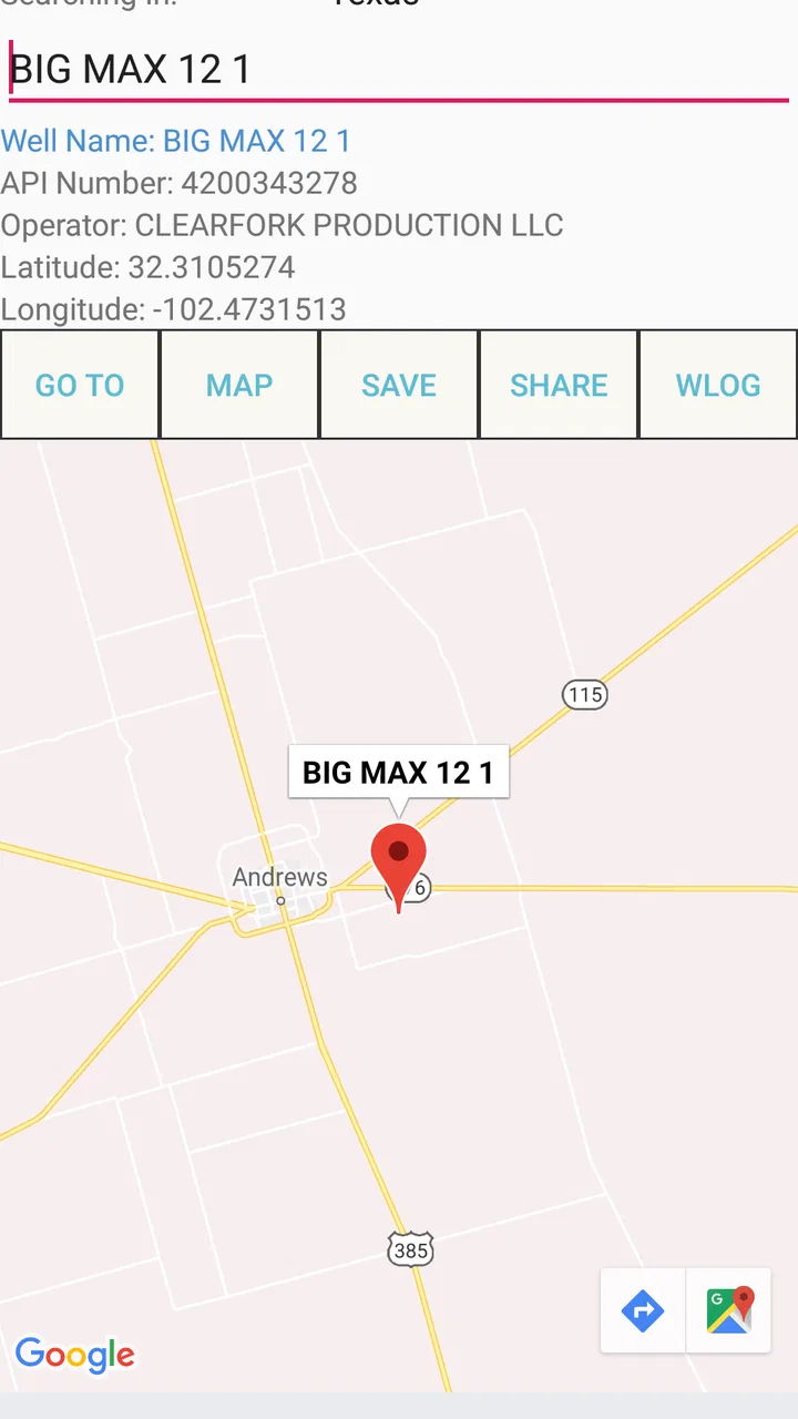
The central capability is straightforward: search for an oil or gas well, view it on a map, and navigate toward it. That sounds simple, but it changes the way I approached a trip. In a normal map app, I would first need the well’s name, coordinates, address, or nearby road. Here, the well itself is the starting point.
You May Also Like

 Pandora - Music & Podcasts
Pandora’s Music Is Easy to Start, but Harder to Recover
Pandora’s strength is its low-effort path from a seed to a station. Its weak spot is how much confidence it asks you to place in connection, setup, and quiet recovery.

 AccuWeather: Weather Radar
AccuWeather Review: A Quick, Clear Forecast for Everyday Decisions
For everyday plans, the best forecast is the one you can understand quickly. AccuWeather makes rain timing, radar, and local conditions easy to act on, with a few trade-offs.

 Hill Climb Racing
Why Hill Climb Racing Still Turns Crashes Into One More Run
A tiny car, a bumpy hill and one more upgrade: Hill Climb Racing keeps resurfacing because its simple chaos makes every near-miss feel personal.

 AliExpress - Shopping App
AliExpress Makes Global Shopping Feel Personal, but Shoppers Bear the Risk
AliExpress turns a global marketplace into a pocket-sized discovery engine. Its reach is useful, its shopping loop compelling, and its trade-offs easy to miss.

 Lords Mobile: Kingdom Wars
Lords Mobile Is a Kingdom-Building Routine, Not a Quick Match
A case-by-case verdict on the building, battles, device demands, and social commitments that make Lords Mobile rewarding for some players and exhausting for others.

 PDF Scanner app - TapScanner
TapScanner Makes Paperwork Easier to Capture, Check, and Share
TapScanner makes scanning with a phone feel less like a rescue operation and more like a dependable step in getting work done. Its capture tools are useful, though not flawless.
More From Our News Desk
View All News


That makes a difference in areas where street addresses are vague or where several rural locations sit far from recognizable landmarks. A well-focused search can help turn a technical destination into something I can work with on a phone. Instead of keeping a separate list of coordinates and then switching between applications, I can use one tool for the discovery step and the travel step.
I found the concept most useful when thinking about a visit as a sequence: identify the site, check where it sits relative to roads, and then decide whether the proposed route makes practical sense. The map is not just a background for a route. It is the place where I verify that the destination is the correct well before setting off.
That distinction matters for field work. A route can look reasonable while still ending at the wrong entrance, an access road, or a nearby facility. I would not treat the app as permission to enter private land or assume that a mapped location is automatically accessible. Its job is to help locate and approach the well, not to settle access rights, road conditions, or site safety.
How I would use it before leaving
My preferred workflow would begin indoors, with a reliable connection and enough time to inspect the destination. I would search for the well, look at its surrounding roads, and compare the map position with any work order, inspection note, or site reference I had. This extra check is important because a well location is more specialized than a normal street address.
After selecting the destination, I would start navigation only once I had confirmed that the route was heading toward the intended site. In a rural setting, the last part of the journey deserves particular attention. A map may show the destination accurately while the final approach still involves an unpaved track, a gate, a private road, or a turn that is easy to miss.
A useful habit is to treat the app as a location tool first and a driving aid second. I would use it to answer, “Where is this well in relation to the roads around it?” Then I would use common sense, local instructions, and current conditions to answer, “Can I actually reach it today?” That separation reduces the risk of following a digital route too literally.
Because the application is specialized, I would also prepare a backup before entering an area with weak service. I would record the well reference and the main roads, and I would avoid assuming that any navigation app can compensate for poor reception or a changed access route. This is not a criticism unique to Go To Well; it is simply more important when the destination is remote and the final approach may be unfamiliar.
A realistic field-visit example
Imagine that I need to visit several wells spread across a rural part of the United States. With a general map application, I might search one location at a time using a coordinate, an address, or a nearby road. That can work, but it creates opportunities for transcription mistakes and repeated switching between a database and the navigation screen.
With Go To Well, I would begin by locating each well inside the specialized app. I could inspect the position of the sites, identify the likely road approach, and decide which visit should come first. Even if I still use another navigation tool for broader route planning, the well-centered view gives me a more relevant starting point than a generic place search.
At the final destination, I would slow down and compare the displayed position with physical clues. A well marker near a road does not necessarily mean the vehicle should stop at that exact point. I would follow posted instructions, stay on authorized roads, and use the app to maintain orientation rather than as a substitute for site procedures.
This workflow also helps when a colleague sends a well reference without a useful postal address. The app’s purpose matches that kind of information better than a consumer map designed around businesses and household destinations. The practical gain is not that every trip becomes effortless; it is that the initial search is less dependent on translating technical location information into ordinary map language.
Where it compares well with ordinary map apps
Google Maps, Apple Maps, and similar services are more versatile for daily travel. They generally make more sense when I need live traffic context, businesses, fuel stops, walking directions, public transport, or a polished route across several types of destinations. Their broad databases and familiar interfaces are hard to beat for general navigation.
Go To Well has a different advantage. Its usefulness comes from putting the well at the center of the experience instead of treating it as an unusual destination that may be difficult to search. For an energy professional, land specialist, contractor, or researcher, that focus can remove a layer of manual work.
I would not choose between the apps as though one must replace the other. A sensible setup may use Go To Well to identify and approach the well, while a broader application handles a long drive, traffic-aware planning, or services along the way. The trade-off is that this two-app workflow requires more preparation, but it can be more practical than forcing one general-purpose app to handle a specialized location task.
The same comparison explains who should skip it. Someone looking for a normal car-navigation app will likely find the narrow scope frustrating. If your destinations are homes, offices, shops, airports, or public facilities, the well database is not the reason to install it. Its value appears only when oil and gas well locations are part of your actual task.
Strengths that become visible in real use
The first strength is focus. The app does not need to persuade me that a well is a normal consumer destination. It is built around that exact category of location, which makes the search process more relevant for specialized work.
The second is the reduction of context switching. When a well reference, map position, and navigation action live in the same purpose-built tool, I can spend less time converting one type of location information into another. That is especially helpful when I am working through multiple sites and need to keep the destination identity clear.
The third is its usefulness as a planning layer rather than merely a driving screen. I can think about the well’s position, nearby roads, and the order of visits before moving. That encourages better preparation than blindly starting navigation from a technical reference.
There is also a practical benefit in its modest entry barrier. The app is free to install, and its content rating is Everyone, so the basic decision to try it is relatively easy for a mixed team or a person investigating whether a specialized tool fits a workflow. The listing also shows optional in-app purchases priced at $29.99 per item, so I would review any purchase screen carefully and avoid assuming that every capability is included at no cost.
Limitations I would plan around
The specialized design means the app is not a complete field-management system. I would not expect it to replace inspection records, access documentation, team communication, safety procedures, or a dedicated asset-management database. Its role is narrower: search, map, and navigation for wells.
I would also avoid treating a map marker as proof of current site conditions. A mapped well can still be difficult to reach because of weather, construction, locked gates, temporary restrictions, or changes to the surrounding road network. The app can guide me toward a location, but it cannot make an unauthorized or unsafe approach acceptable.
Another trade-off is the likely need for careful destination verification. Specialized locations can be close together or described with technical identifiers that are easy to confuse. Before driving, I would compare the selected well with the job reference and surrounding geography. That small pause is more valuable than immediately following the first search result.
The app’s audience is also naturally smaller than the audience for a mainstream navigation service. Its average rating is 3.9 from around seventy-seven ratings, with about forty written reviews, and it has passed ten thousand installs. Those figures suggest a focused utility with a modest user base rather than a universally adopted navigation platform. I would interpret that as a reason to test it against a real work route before depending on it for an important visit.
The current version is 1.145, and the app was released on May 16, 2019. For me, those details reinforce the need for a quick practical trial on the phone I intend to use. I would check that searching, mapping, and navigation behave as expected before leaving for a remote location, especially if the trip cannot easily be repeated.
Small habits that make the app more useful
My first tip is to search before you are under time pressure. A well visit often has more consequences than an ordinary stop at a shop, and preparing the destination at home gives me time to notice an unexpected road layout or a mismatch with the work notes.
My second tip is to use the map context as a verification tool. I would not only read the well label; I would inspect the nearby road pattern and the direction from which the route approaches. This can reveal when the navigation endpoint is close to the site but not necessarily at the correct entrance.
My third tip is to separate “located” from “reachable.” Once I find the well, I would confirm access through the responsible operator, landowner, supervisor, or local instructions where appropriate. That distinction prevents a common navigation mistake: assuming that a precise point on a map guarantees a legal and usable road.
My fourth tip is to keep a written or offline reference for the final destination. I would note the well identifier, the last recognizable road, and the planned approach. If the phone loses service or the route changes, those details can help me stay oriented while I reassess the situation.
Finally, I would use the app for one or two representative wells before rolling it out to a larger team. A short trial can show whether its search behavior matches the identifiers used by the organization and whether the navigation workflow is comfortable on the chosen device. That is a better test than judging it only from the store summary.
Who gets the most value
I see the strongest fit for people who regularly deal with oil and gas well locations in the United States: field inspectors, maintenance crews, environmental consultants, land professionals, researchers, and contractors. For these users, the specialized search target is not a novelty; it is the reason the trip exists.
It may also help occasional users who receive a well location without a familiar street address. Even if they keep a general map app for the long journey, this tool can make the destination-identification stage less awkward. The benefit is greatest when the person already understands that the final approach requires independent judgment.
I would be more cautious recommending it to casual travelers, delivery drivers, or anyone expecting a universal navigation companion. They may install it, discover that its subject matter is limited to wells, and gain little from it. A broad map service is the better choice for ordinary errands and mixed destination types.
For professional teams, the purchase model deserves attention. The download is free, but optional items are listed at $29.99 each, so I would establish who needs paid functionality and whether it fits the team’s workflow before making assumptions about total cost. The app’s Everyone rating does not mean every professional use is automatically risk-free; field decisions still require appropriate training and local procedures.
My recommendation after using it
I would recommend Go To Well to a friend only if that friend had a concrete reason to search for and travel to oil or gas wells in the United States. In that situation, its narrow purpose is a genuine advantage. It gives the well location priority and can simplify the transition from a specialized reference to a map-based approach.
I would not recommend it as my only navigation app for daily life. It is better understood as a focused companion for well-related travel, not a replacement for a full mapping ecosystem. The most reliable setup is to use it for locating and checking the target, then combine that information with ordinary route planning, access confirmation, and sensible preparation.
Overall, the app earns its place through relevance rather than breadth. If your destination is a well, its focused workflow can save valuable searching and reduce location confusion; if your destination is anything else, that same focus becomes unnecessary. Sunland Software has made a tool for a particular job, and my honest view is that it works best when users respect that boundary instead of expecting a general-purpose navigation experience.
FAQs for Go To Well
01What is Go To Well and what can I use it for?
Go To Well is a wellness-focused app designed to help users organize and improve everyday health habits. Depending on the features available in your region, it may provide access to wellness content, activity or lifestyle guidance, progress tracking, and tools for maintaining healthier routines. It is best viewed as a companion for personal wellbeing rather than a replacement for professional medical advice.
02Is Go To Well free to download and use?
Go To Well may be available as a free download, although some features, programs, or premium content can require payment or an eligible membership. Before installing it, check the app store listing for current pricing, subscriptions, trial conditions, and in-app purchases. You should also review the renewal terms so you understand whether a subscription continues automatically after a trial period.
03Do I need to create an account to use Go To Well?
Many of the app’s personalized features may require you to register or sign in. An account can allow Go To Well to save your preferences, track progress, synchronize information across devices, or provide access to programs connected with your organization or service provider. During registration, review the requested permissions and privacy information before entering personal or health-related details.
04Is Go To Well suitable for medical treatment or serious health conditions?
Go To Well should not be treated as a diagnostic or treatment service unless the app’s official description clearly states otherwise. Wellness recommendations, reminders, and tracking tools can support healthy routines, but they cannot replace a qualified doctor, therapist, dietitian, or other healthcare professional. If you have a medical condition, are taking medication, or notice concerning symptoms, seek professional guidance.
05What devices and permissions does Go To Well require?
Before downloading Go To Well, confirm that your Android or iOS device meets the current operating-system requirements shown in the official store. The app may request permissions such as notifications, internet access, health or activity data, camera access, or location, depending on the features you use. Grant only permissions that make sense to you, and adjust them later in your device settings if necessary.
Pros
- Simple interface makes wellness routines easy to start.
- Useful reminders can help users maintain consistent habits.
- Short activities fit conveniently into busy daily schedules.
- Progress tracking provides motivation and a sense of achievement.
- Suitable for beginners who want approachable wellness guidance.
Cons
- Some features may require a paid subscription or in-app purchase.
- Personalization options may feel limited for experienced users.
- The app may need regular internet access for certain content.
- Reminder notifications could become repetitive over time.
- Wellness advice may not replace guidance from a qualified professional.

Go To Well
Gallery